
Trinidad traffic exercises: Police arrest four and issue penalties
2024-06-03 04:52:28
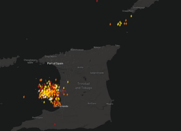
While no casualties or injuries have been reported from the 420 lightning strikes in Trinidad, authorities are cautioning residents about the possibility of severe weather and potential damage.
Lightning in Trinidad
Trinidad: In a shocking and extraordinary turn of events, an isolated severe thunderstorm activity produced 420 lightning strikes in 30 minutes on Sunday afternoon over west-central Trinidad and the gulf of Paria.
As per reports no casualty or injury has been reported from these lighting strikes, but authorities warn residents of potentially damaging weather conditions. The lightning strikes were caused by torrential rains between 4:15pm and 4:45 pm, leading to street flooding in Couva, Point Lisas and California.
Although the storm has begun to move towards the South-westward, while forecasters still warn residents of rough seas and hazardous conditions, especially for small craft operators.
<iframe src="https://www.facebook.com/plugins/video.php?height=476&href=https%3A%2F%2Fwww.facebook.com%2FMattDevittWeather%2Fvideos%2F720675207639698%2F&show_text=false&width=334&t=0" width="100%" height="476" style="border:none;overflow:hidden" scrolling="no" frameborder="0" allowfullscreen="true" allow="autoplay; clipboard-write; encrypted-media; picture-in-picture; web-share" allowFullScreen="true"></iframe>
Experts from the met department say that the storm's intensity was linked to the influence of Invest 99L, a tropical disturbance which is currently the east of the Lesser Antilles. The disturbance is currently being actively reviewed by the US National Hurricane Center, (NHC).
The NHC says that Invest 99L currently has a very low chance of tropical cyclone development over the next 48 hours and the coming week, however, it continues to make the weather worse across the Caribbean islands. The system is expected to move further from the Lesser Antilles bringing heavy showers, and gusty winds from northern Barbados to Antigua.
The Trinidad and Tobago met department says that light winds and slow-moving thunderstorms will continue to affect the country on Monday with scattered showers expected in the afternoon. These showers will be affecting parts of the northern and central Trinidad and parts of Tobago.
Authorities have not issued any warning yet currently but are urging residents to remain vigilant of sudden flooding especially in flood prone areas. Video footages shared by residents across social media platforms on Sunday showed streets flooded across Trinidad with severe waterlogging. These conditions seem to persist further with heavy rains expected over the coming days.
As per the National Hurricane Center, Trinidad and Tobago is not directly in the path of Invest 99L but will get affected from the outer moisture bands fueling more dangerous thunderstorm activity and heavy rainfall.


