
Three students consume marijuana at Bahamas High School campus, hospitalized
2024-05-01 03:49:03
Authorities warn that saturated soil increases the risk of landslides and flooding in low-lying areas.
Flash Flood Watch Issued for St Kitts and Nevis after heavy rainfall
St Kitts and Nevis: A Flash Flood Watch has been issued for St Kitts and Nevis due to continuous rainfall over the past 24 hours. The National Emergency Management Agency (NEMA) advised that the ground is saturated and urged the public to exercise caution, especially in areas prone to landslides and rockfall. The advisory remains in effect until October 18, 2025.
According to the Meteorological Department, a flash of lightning, accompanied by a loud sound of thunder, at 5:15 A.M., knocked out the electricity supply in the area of Keys Village, four miles outside of Basseterre on Friday, leaving the area in darkness.
Another thunder bolt occurred at 5:19. The area has been experiencing thunder, lightning and bouts of rain during the night. It was not immediately known if other areas were affected by the loss of electricity.
The Flash Flood Watch, which is in effect for low-lying and flood-prone areas in St Kitts and Nevis, has been extended until 12 noon. There is also a possibility of a further extension if it becomes necessary. A Flash Flood Watch means that moderate to major flooding is possible, but not imminent in the watch area.
Residents and citizens in low-lying and flood-prone areas should make preparations for flooding to safeguard life and property. The citizens are asked to be prepared to move to higher ground if flooding rains develop or a Flash Flood Warning is issued.
The NEMA has advised that the citizens must avoid parking in known waterways and they must exercise caution when using roadways with high levels of water accumulated or standing water. They must avoid crossing these areas in vehicles or on foot.
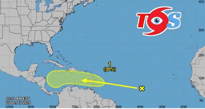
According to the Meteorological Department, a tropical wave currently located over the central tropical Atlantic
is associated with a large area of showers and thunderstorms. Some gradual development of this system is possible over the next several days as it moves westward at 15 to 20 mph. Regardless of development, heavy rainfall and gusty winds are possible as the system moves across the Windward Islands late this weekend and enters the Caribbean Sea by the early to middle part of next week.
* Formation chance through 48 hours...low...10 percent.
* Formation chance through 7 days...low...30 percent.


