
 Hurricane Erin turned into Category 4 Hurricane
Erin physical confrontation in relatives left two injured
2024-06-26 15:59:01
NHC has stated in a recent social media statement that Category 5 Hurricane Erin is expected to grow even bigger in size as it moves from the Northern Leeward Islands.
Where is Hurricane Erin?
Tropical Storm Erin which has been approaching the Caribbean, has strenghthened into the first ever Hurricane of the Atlantic Hurricane Season as of Friday morning. Hurricane Erin is forecasted to become a category 3 or 4 hurricane as it approaches the northern Leeward islands.
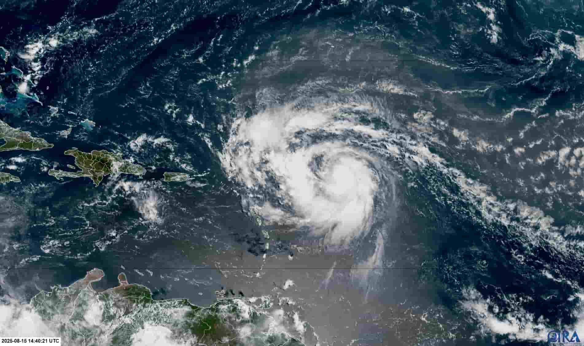
Erin currently has peak wind speeds of around 75mph which could increase to 130mph as it moves ahead.As per reports, the Caribbean nations specifically in the north are bracing for the potential effects of the hurricane.
Authorities have urged residents to exercise precautions and to rely only on official updates through government or reliable sources. The Leeward island countries remain at the major threat of being hit by Erin, which is notably the first ever hurricane of the Atlantic Hurricane Season 2025.
Stay Tuned with Associates Times for all the live updates related to Hurricane Erin.
Erin went up from a Tropical wave to a Category 1 by August 15, and then immediately intensified to a Category 5 hurricane by August 16 with sustained winds of 160 mph and central pressure of around 915-917mb. With such a rapid intensification, Erin became the first ever hurricane to cross such limits in slight more than 24 hours.
After peaking, Erin entered to an eyewall replacement cycle, that weakened it down to a Category 3 hurricane. But soon after it intensified back to Category 4 posing threat to the US.
Erin is now at Category 4 strength with winds nearing 130 mph. It is currently located well east of the US coast and moving northwest at roughly 12 mph. Forecasts indicate that the hurricane will remain offshore as of now.
Though a landfall is expected, Erin continues to cause trouble across massive area. Dangerous rip currents are affecting the Bahamas, Bermuda, US East Coast, Puerto Rico and the Atlantic Canada in the coming days.
Island nations including Puerto Rico, Turks and Caicos, Bahamas, and Leeward Islands following the passage of Erin are facing intense rainfall, landslides, flash flooding and ravaged infrastructure.
Puerto Rico separately reported 6+ inches of rainfall across different spots and 150,000 power outages. Tropical storm watches and warnings were also in effect across different islands.
Hurricane Erin which has strenghthened to Category 5 has moved towards the north and now poses no direct threat to Dominica and surrounding caribbean islands. The hurricane has moved towards the north and continues to grow in size.
While Dominica remains out of the direct threat from Erin, it could still cause heavy rainfall and thunderstorms leading to flooding in the seas. Emegency officials and met department has advised to stay cautious and exercise precaution as Erin's passage could also lead to rough seas.
The National Hurricane Center for Atlantic has stated in a recent statement that Hurricane Erin is expected to grow even bigger in size as it passess through the northern leeward islands and the US. A tropical storm watch has also been issued for Turks and Caicos island.
NHC also warns that life threatening surf and rip currents are expected along the US east coast beaches beginning Monday and could last most of next week.
<blockquote class="twitter-tweet"><p lang="en" dir="ltr">Category 5 Hurricane <a href="https://twitter.com/hashtag/Erin?src=hash&ref_src=twsrc%5Etfw">#Erin</a> Key Messages for the 5pm advisory on 8/16: A Tropical Storm Watch has been issued for the Turks and Caicos Islands. Erin is expected to grow in size. Life-threatening surf and rip currents are expected along U.S. east coast beaches beginning Monday… <a href="https://t.co/5F2aJZ6gpt">pic.twitter.com/5F2aJZ6gpt</a></p>— National Hurricane Center (@NHC_Atlantic) <a href="https://twitter.com/NHC_Atlantic/status/1956823583512281378?ref_src=twsrc%5Etfw">August 16, 2025</a></blockquote> <script async src="https://platform.twitter.com/widgets.js" charset="utf-8"></script>
Hurricane Erin has strenghthened to a Category 5 in a little over 24 hours becoming the fastest intensifying hurricane ever in history. The storm with sustained winds of more than 160 mph is expected to cause heavy damage to the Caribbean islands in form of flash flooding and heavy rainfall.
Caribbean Airlines, in order to accomodate affected passengers has launched recovery flights to St Maarten. The airline in a recently released statement said that they are conducting re-accomodation services for ticketed and confirmed passengers traveling to and from St Maarten, for passengers affected by flight cancellations on August 15 due to Hurricane Erin.
<iframe src="https://www.facebook.com/plugins/post.php?href=https%3A%2F%2Fwww.facebook.com%2Fcaribbeanairlines%2Fposts%2Fpfbid0fWXPVy6TbfaZFpAeqqHpazWonJDkSTrraHF2b4z4SXao4o3rRFebW57cYR72mJwEl&show_text=true&width=500" width="500" height="647" style="border:none;overflow:hidden" scrolling="no" frameborder="0" allowfullscreen="true" allow="autoplay; clipboard-write; encrypted-media; picture-in-picture; web-share"></iframe>
A local from Dominica, while sharing his experience with Associates Times from the early hours of 16th August said the weather was hot.
"Weather is so hot today. Locals say, hurricane erin is sucking all the moisture from the air, which eventually will make it strong. It was hotter before during Maria. But, here, we are still experiencing heat," He stated.
Hurricane Erin has now strengthen to Category 5 and is passing the north of the Norhern Leeward Islands. Outer rainbands are affecting teh Northern Leeward Islands and causing inclement weather conditions in the islands.
<blockquote class="twitter-tweet"><p lang="en" dir="ltr">Hurricane <a href="https://twitter.com/hashtag/Erin?src=hash&ref_src=twsrc%5Etfw">#Erin</a> Advisory 21A: Category 5 Erin Passing North of the Northern Leeward Islands. Outer Rainbands Affecting the Northern Leeward Islands. <a href="https://t.co/tW4KeGdBFb">https://t.co/tW4KeGdBFb</a></p>— National Hurricane Center (@NHC_Atlantic) <a href="https://twitter.com/NHC_Atlantic/status/1956770944447324290?ref_src=twsrc%5Etfw">August 16, 2025</a></blockquote> <script async src="https://platform.twitter.com/widgets.js" charset="utf-8"></script>
Hurricane Erin has turned into Category 4 Hurricane with a wind speed of 13 mph. According to the Met Department, winds has jumped 55 mph in just under 13 hours and Erin was located 150 miles northeast of Anguilla. It is also moving west-northwest at 20 mph with strong and gusty winds.
It is expected to further strengthen during the day and the Erin will continue tracking west-northwest over the next couple of days.
The major airlines of the Caribbean including, Caribbean Airlines, LIAT 2020 and interCaribbean Airways have cancelled the flights to different destinations in the region. Due to the passage of the Hurricane Erin, the flights of these airlines got cancelled and rerouted to operate flights in Trinidad and Tobago, Barbados and Puerto Rico.
There is no watch or warning in place for the countries such as St Kitts and Nevis and others.
Hurricane Erin converted into Category 1 to Category 2 today with a sustained window of 100mph and a central pressure of 979 mb. As per the met department, Erin is likely to convert into Category 4 within 24 to 36 hours, adding that the US East Coast will see high surf with the possible height of 2 to 6 feet by Tuesday.
However, Tropical Storm Watch discontinued for Barbuda as Hurricane Erin remains on a track which will spare the Leeward Islands from its strongest winds.
Tropical Storm Erin has been strengthened into a Hurricane and is projected to remain hurricane by this weekend with the potential of category 4. The centre of the hurricane is expected to stay 500-600 miles off the Florida coast next Tuesday and Wednesday.
Tropical Storm Watches are issued for several of the islands in the Leewards and the rain has started in the Caribbean region.
The National Hurricane Centre has stated that Hurricane Erin will pass near or north of the Leeward Islands on Saturday, as it moves quickly West-Northwestward.
<blockquote class="twitter-tweet"><p lang="en" dir="ltr">Hurricane <a href="https://twitter.com/hashtag/Erin?src=hash&ref_src=twsrc%5Etfw">#Erin</a> Advisory 17A: Erin Moving Quickly West-Northwestward. Expected to Pass Near Or North of the Leeward Islands On Saturday. <a href="https://t.co/tW4KeGdBFb">https://t.co/tW4KeGdBFb</a></p>— National Hurricane Center (@NHC_Atlantic) <a href="https://twitter.com/NHC_Atlantic/status/1956409562384245007?ref_src=twsrc%5Etfw">August 15, 2025</a></blockquote> <script async src="https://platform.twitter.com/widgets.js" charset="utf-8"></script>
Streets have started to flood already, in the corner of the Southern Main Road and Caparo Valley Brasso Road in the vicinity of KFC Montrose, as hurricane Erin approaches the caribbean. The flooding and heavy rainfall is the result of the inclement weather conditions created through the influence of Hurricane Erin on atmosphere.
<iframe src="https://www.facebook.com/plugins/video.php?height=476&href=https%3A%2F%2Fwww.facebook.com%2FTTWeatherCenter%2Fvideos%2F1256255269137799%2F&show_text=false&width=267&t=0" width="267" height="476" style="border:none;overflow:hidden" scrolling="no" frameborder="0" allowfullscreen="true" allow="autoplay; clipboard-write; encrypted-media; picture-in-picture; web-share" allowFullScreen="true"></iframe>
As per the latest updates from 11:00 am ET, Hurricane Erin was located at around 460 miles east of the Leeward islands. The Centre of the storm is likely to move near or just north of the Leeward Islands by weekend.
<blockquote class="twitter-tweet"><p lang="en" dir="ltr">Hurricane <a href="https://twitter.com/hashtag/Erin?src=hash&ref_src=twsrc%5Etfw">#Erin</a> Advisory 17: Erin Becomes the First Hurricane of the 2025 Season. Expected to Pass Near Or North of the Leeward Islands On Saturday. <a href="https://t.co/tW4KeGdBFb">https://t.co/tW4KeGdBFb</a></p>— National Hurricane Center (@NHC_Atlantic) <a href="https://twitter.com/NHC_Atlantic/status/1956367281778253889?ref_src=twsrc%5Etfw">August 15, 2025</a></blockquote> <script async src="https://platform.twitter.com/widgets.js" charset="utf-8"></script>


 announced the completion of the project and added that the project has been completed at a cost of $10 million.")
