
PM Holness announces $1 Billion rebuilding plan for Jamaica post BERYL
2024-07-19 11:56:41
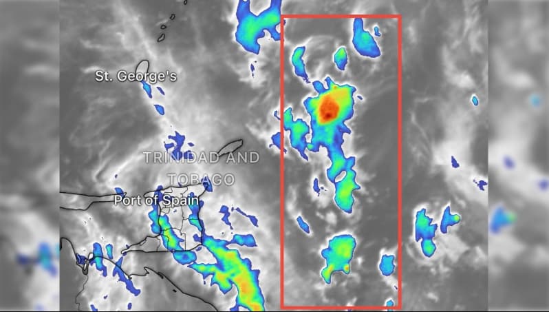
Mid-morning will see increased activity, with peak conditions expected to affect Trinidad’s western half, northwestern mountains, and northeastern Tobago.
As a large tropical wave approaches, mid-morning activity intensifies, impacting Trinidad’s western half and northeastern Tobago.
Trinidad and Tobago: A large Tropical Wave is expected to affect Trinidad and Tobago from early Friday into late Saturday afternoon. As per the met department, the activities related to the storm are expected to develop over the Caribbean sea, aiming to impact the eastern region of the country with widely scattered showers and possible isolated thunderstorms.
The mid-morning is expected to see an increase in activity and is likely to have spread across much of the country. Peak activity is also expected to favour Trinidad’s western half and northwestern mountains with northeastern Tobago also likely to see enhanced activity.
The met department noted that they are expecting mainly settled conditions that will be returned by sunset and there will be a chance of scattered showers and other inclement conditions. As of Saturday, early morning activities are likely to spread across the country, especially around Tobago and Eastern and Southern Trinidad.
In the early morning, the conditions will be associated with enhanced cloudiness and there will be showers that will be widely scattered. There are also chances of the isolated thunderstorms across Tobago and eastern Trinidad which will be continued through mid-morning.
During the mid morning to late afternoon, there will be chances of lingering and instability moisture which is likely to support isolated to widely scattered showers. It will also feature the isolated thunderstorms which will be mainly over southern and southwestern Trinidad.
Gusty winds, heavy rainfall and possible flooding which is likely near stronger activity and mainly calm conditions are expected to return nationwide by sunset.
The effects from northerly long-period swells are quickly diminishing. There is the presence of westerly swells which will slightly exacerbate breaking waves at high tides, on sheltered areas of exposed coasts.
Isolated showers and possible brief isolated thunderstorms affecting parts of southern Trinidad, ahead of a mostly settled evening.
A few additional isolated showers have developed over parts of Southern Trinidad, mainly near St. Mary’s, Moruga, and portions of the Penal–Debe region, drifting westward.
Activity is expected to gradually diminish through the next several hours, with mostly calm and settled conditions anticipated by sunset.

 Heads of Government meeting which took place in Barbados recently.")


